Impacts of Climate Change Will Make You More Worried

Author: Md. Mahadi Hasan

Climate change is one of the greatest environmental, social, and economic threats that the world faces today. With 160 million people, Bangladesh is one of the largest deltas in the world which is highly vulnerable to natural disasters because of its geographical location, flat and low-lying landscape, population density, poverty, illiteracy, lack of institutional setup etc. Moreover, the adverse effects of climate change – especially high temperature, sea-level rise, cyclones and storm surges, salinity intrusion, heavy monsoon downpours etc. has aggravated the overall economic development scenario of the country to a great extent.

Bangladesh is under great threat of climate change because of its geographic location. Flood, cyclone, drought, river bank erosion will be increased in Bangladesh due to climate change.

Impacts of Climate Change in Bangladesh


You Need to Know What Climate Change Actually Means

Intergovernmental Panel on Climate Change (IPCC) defines climate change as “a change in the state of the climate that can be identified (e.g. using statistical tests) by changes in the mean and/or the variability of its properties, and that persists for an extended period, typically decades or longer. It refers to any change in climate over time, whether due to natural variability or as a result of human activity”.

Climate change is the greatest threat that the world is facing today. Greenhouse effect prevents the heat radiation from earth which causes rising in land and ocean temperature. Major greenhouse gases are H2O, CO2, CH4, and O3. China, USA, India, Russia, and Brazil are the major greenhouse gas emitters. Major sources of greenhouse gas emission are transportation, fossil fuel combustion, industrialization, electricity generation etc. There are many impacts of climate change like increase in world temperature, sea level rise, natural disaster etc. We should use green energy, green products, green fuel to prevent climate change.

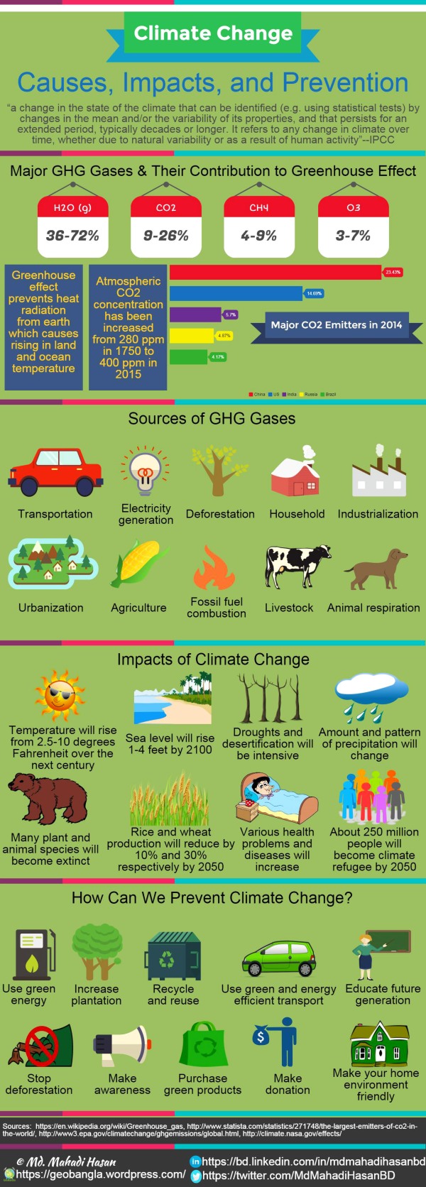
Climate Change: Causes, Impacts, and Prevention (Infographic)

Climate change generally refers to global changes in temperature, wind, precipitation, the length of seasons as well as the strength and frequency of extreme weather events like droughts and floods.

Warming of the climate system is unequivocal, as is now evident from observations of increases in global average air and ocean temperatures, widespread melting of snow and ice and rising global average sea level.

The period from 1983 to 2012 was likely the warmest 30-year period of the last 1400 years in the Northern Hemisphere. The globally averaged combined land and ocean surface temperature increased about 0.85°C over the period from 1880 to 2012. Increases in sea level are consistent with warming. Over the period 1901 to 2010, global mean sea level rose by 0.19m per year (IPCC: Climate Change 2014: Synthesis Report).


What Are The Causes of Climate Change?

The pollution of the environment such as greenhouse gas emissions, fossil fuel burning, and deforestation are the most significant cause of climate change.

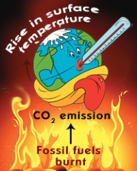
The world climate is changing mostly because of greenhouse effect. Water vapor (H2O), carbon dioxide (CO2), CFC, methane (CH4), nitrous oxide (N2O) etc. are common greenhouse gases. China, USA, India, Russia, and Brazil are the major greenhouse gas emitters.

The heat of the sun usually goes back to the outer space by radiation. But the greenhouse effect prevents the radiation of the heat. For this reason the average temperature of the world is increasing. The main causes of greenhouse gas emissions are:

Anthropogenic Greenhouse Gas (GHG) Emissions:

Anthropogenic GHG emissions have increased since the pre-industrial era, driven largely by economic and population growth, and are now higher than ever. Global GHG emissions have been increased about 70% between 1970 and 2012. Between 1750 and 2011, cumulative anthropogenic CO2 emissions to the atmosphere were 2040 ± 310 GtCO2.

Fossil Fuel Combustion:

Emissions of CO2 from fossil fuel combustion and industrial processes contributed about 78% of the total GHG emissions increase from 1970 to 2010.

Deforestation and Urbanization:

Everyday over 5500 acres of rain forest are destroyed resulting about 0.4% rise of CO2 level per year.


Impacts of Climate Change in Bangladesh

Bangladesh experiences different types of Natural Disasters almost every year because of the Global Warming as well as climate change. More than 100 types of changes have been observed in the environment of Asia because of climate change. Bangladesh is under great threat of climate change because of its geographic location. The probable threats to Bangladesh are:

Disappearing Seasons of Bangladesh:

The seasons of Bangladesh are disappearing due to climate change. Summer and rainy season are prolonging while winter season is shrinking. Autumn and Dewy season are vanishing.

Flooding in Coastal Areas:

Almost 80% of the total area of the country is prone to flooding. According to IPCC, the sea level of the Bay of Bengal will be increased about one meter by this century. As a result a huge amount of coastal area of Bangladesh will be submerged under water.

Natural Disasters:

Flood, cyclone, drought, river bank erosion etc. will be increased and intensified due to the change of climate.

Crop Production and Food Security:

The average temperature of Bangladesh will be increased up to 2 degree Celsius by the year of 2050 due to global warming. It will reduce the production of rice up to 10% and wheat up to 30% due to the shortage of water for irrigation.

Fisheries and Forests:

The fisheries sector has also experienced an adverse effect because of the impacts of climate change. There are around 260 species of fish in the country and almost all the varieties are sensitive to specific salt and freshwater conditions.

About 75% area of mangrove forest, the Sundarban, will be submerged if the sea level rises up to 45cm. If the seal level rises over 1 meter, the whole mangrove forest will be submerged under sea water.

Water Resources:

The effects of climate change on the surface and groundwater resources will be very severe and alarming. The rivers are becoming dry and salinity intrusion is taking place. As a result, there will be huge crisis for fresh water. Irrigation, fishery, industrial production, navigation will also be affected to a great extent.

Public Health:

Various health problems and diseases will be increased due to climate change. Frequent floods and cyclonic storm surges are contaminating water resources increasing water borne diseases such as cholera, diarrhea etc. Some other diseases like hepatitis-B, cerebral contamination, meningitis, polio will be increased. Rise of temperature will favor for pests and pathogens that will increase dengue, malaria, etc.

Climate Refugee:

Only 1 meter sea level rise in Bangladesh will lead to 15% loss of its total land area and around 30 million people living in the coastal areas of Bangladesh would become climate refugees.


Conclusion

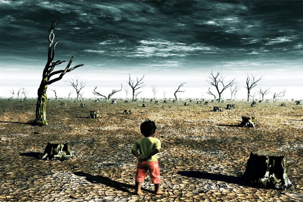
Global climate change will affect the people and the environment in many ways. Some of these impacts like strong hurricanes and severe heat waves can be life threatening. It is difficult to sustain fight against the nature. But the nature usually does not behave rudely with the human beings. We, the human beings are mostly liable for making the nature unruly. We have destroyed our environment intentionally or unintentionally. The more we learn about how climate change will affect people and environment, the more we can say why people need to take action to reduce the greenhouse gas emissions. Being one of the most affected and vulnerable countries of the world due to climate change, Bangladesh is certainly well positioned to raise its voice and bargain for getting for a fair share in a global climate deal.

Great Findings on the Dug Wells Water Quality in Old Dhaka

Author: Shovon Barua

Dhaka, the capital and central city of Bangladesh, with a population of over 15 million, suffers from both water scarcity and water pollution. Dhaka city is dependent mainly on groundwater resources from fluvio-deltaic Dupi Tila aquifer of Pliocene age. The water productivity is about 2180 MLD (million liter per day) against the current demand for 2250 MLD that is withdrawn by about 622 DWASA tube wells with 3040 km long pipeline network. City of Dhaka immediately requires alternative water resources. This study was conducted to investigate the water quality of existing dug wells to determine the potential of dug wells to use as alternative source of safe water.

Geology of Dhaka City

Physiographically Dhaka city is situated in the southern half of the Madhupur Tract and Floodplain area with southern river system. Regional elevation of the area gradually declines towards Buriganga River on the south and the elevation ranges from 10m to 17m but is generally around 14m above mean sea level. Geologically Dhaka city belongs to Bengal Foredeep and is situated in the Pleistocene uplifted block (Madhupur Tract) within the passive margin surrounded by subsiding floodplains bounded on the west by a series of NW-SE trending en-echelon faults including the Dhamrai, Maijail and Kaliakoir ones. Land surface is covered by gray floodplain and non-Cretaceous floodplain soils. Stratigraphically, Old Dhaka is characterized by hundreds of meters thick unconsolidated sequence of fluvio-deltaic deposits many composed of gravels, sands, silts and clays of Plio-Pleistocene age.

Procedures

There were as many as 120-150 Dug wells in Old Dhaka during the British tenure. Now-a-days the figure is reduced to 50-60. Among them thirty six dug wells water samples were collected randomly and four river water samples were collected from four different boat terminals in Buriganga River during both dry and wet periods. Analytical results of samples have been evaluated and compared with various drinking water quality parameters following guidelines of World Health Organization (WHO, 2011), Department of Environment, Bangladesh (DOE, 1997) and United States Environmental Protection Agency (USEPA, 2011).

Great Findings on the Water Quality of Dug Wells in Old Dhaka, Bangladesh Revealed. Location map showing the position of sampling points in Old Dhaka

Location map showing the position of sampling points in Old Dhaka, Bangladesh

Findings

The hydrochemical classification shows that both dug wells and river water samples are Ca2+-HCO3 type indicating that the dug wells receive water from the adjacent Buriganga River. Above 50% dug well water samples exceed the DW standard of Ca2+, K+ and Fe2+ ions and below 25% Buriganga river water samples are within the acceptable limits during both dry and wet periods. Calcium carbonate and bleaching powder are used to treat water from dug wells for domestic purposes. Plastering is employed to avoid the caving in and also to keep the dug well wall dry and algae-free. It has not been deciphered whether the dug wells are being recharged from surface water flowing directly into the well or groundwater that has recharged via riverbank filtration. It is urgent to ensure the proper maintenance of these historical dug wells by the concerned authorities as well as to mitigate water scarcity problem using dug well as alternative water resource.

Know the Wonderful Geology of The SW Coastal Belt of Bangladesh

Author: Md. Mahadi Hasan

The coastal belt of Bangladesh consists of 19 coastal districts out of 64 districts encompassing 147 upazilas including the exclusive economic zone (EEZ) and constitutes 32 percent of the area and 28 percent of the population of Bangladesh. The coastal belt of Bangladesh forms the lowest landmass and is part of the world’s largest delta called the Bengal Delta or Ganges-Brahmaputra Delta. The coast of Bangladesh is about 710km long. The southwestern coastal belt belongs to the Tidal Delta and parts of Satkhira district belongs to the inactive Ganges delta, Parts of Khulna district belongs to both active and inactive Ganges delta and parts of Bagerhat district belongs to the active Ganges delta respectively.

The Exposed coast and interior coast of Bangladesh modified by Md. Mahadi Hasan after: PDO-ICZMP,2003

The Exposed coast and interior coast of Bangladesh modified by Md. Mahadi Hasan after: PDO-ICZMP,2003

Based on geomorphologic features, the coastal areas of Bangladesh have been divided into three distinct regions viz. the eastern region, the central region and the western region and the study area belongs to the western region which is characterized by dense mangrove forest and deeply scoured tidal channels. According to PDO-ICZMP (2003), the coastal zone of Bangladesh has been classified into exposed coast and interior coast (figure) based on cyclonic storm surges, salinity and tidal influence. 12 districts out of 19 coastal districts comprising 48 Upazilas are exposed to the Bay of Bengal or lower estuaries and are defined as exposed coast and the remaining 99 Upazilas of the coastal districts are defined as interior coast.

Geology

The geology of the southwestern coastal belt of Bangladesh is characterized by active tectonism, sea level fluctuation and tidal activity. Tectonically the study area belongs to the Foredeep of the Bengal Deep (geosynclinal) Basin which is characterized by only mild or no folding. So the sedimentary layers are generally horizontal. The coastal zone is composed of Quaternary sediments carried by the Ganges-Brahmaputra-Meghna river system forming an overlapping deltaic arc. About 1.67 billion tons of sediment is carried annually by this mighty river system and 970 billion cubic meter of water is discharged into the Bay of Bengal. This huge load of sediments finds its way into the Bengal deep sea fan. The southwestern coastal belt belongs to the tidal delta and partly of both active and inactive Ganges delta and is composed of floodplain sediments mainly clay, silty clay, sandy clay and sand. Depositional pattern is very complex and it is difficult to find a regular or continuous succession but it shows a heterogeneous mixture of sand, silt and clay.

Hydrology

The southwestern coastal belt is crisscrossed by a large number of rivers and their tributaries. The major rivers of Satkhira district are the Morichap River, Kholpotua River, Betna River, Raimangal River, Hariabhanga River, Ichamati River, Betrabati River and Kalindi-Jamuna River. The major rivers of Bagerhat district are the Panguchi, Daratana, Madhumati, Pasur, Haringhata, Mongla, Baleswar, Bangra and Goshairkhali whereas the major rivers of Khulna district are the Rupsa-Pasur, Bhairab, Shibsha, Dharla, Bhadra, Ball, and Kobadak. The Rupsa River is formed by the union of Bhairab River and Atrai Rivers. Near Chalna, it changes its name to Pasur River and flows into the Bay of Bengal. The Pasur River is tributary of the Ganges River. The Bhairab River originates from Tengamari border of Meherpur district and bisects the Khulna city into two parts and passes through the Jessore town.

Hydrometeorology

The southwestern coastal belt is experienced with three distinct seasons viz. hot humid summer from March to June, cool rainy monsoon from June to October and cool dry winter from October to March. About 1500 to 2000mm rainfalls occur annually over this area of which about 70% rainfalls occurs during the monsoon period whereas about 20% and 10% rainfall occur during the summer and winter period respectively. Evaporation changes throughout the year of the study area and ranges from 1.34mm to 4.3mm. Evaporation starts increasing from February and attains its peak at May when maximum temperature occurs and minimum evaporation occurs on December or January. The temperature of this area varies throughout the year. During the months of hot humid summer, the temperature reaches high of around 35.4°c in May and during the winter the temperature becomes as low as of 13.8°c in January.

Hydrogeology

The water level fluctuates between 1 to 2.6m in Khulna and 1.5 to 10m in Satkhira respectively. The water level occurs mostly within 1.75m in Khulna and 5m in Satkhira. The ground water level of this area is influenced by tidal activity. The river stage starts rising from the beginning of March whereas the ground water level starts rising from the late of April.

The southwestern coastal belt of Bangladesh especially the Khulna-Satkhira coastal belt is endowed with multi-layer prolific aquifers composed of deltaic sediments-a complex mixture of sand silt and clay. Hydrogeologically the southwestern coastal belt of Bangladesh belongs to the Holocene Coastal Plains (Zone-V). The sandy sediments forming the aquifers are not continuous but rather sand lenses interbedded with silts and clays with significant overlapping. Seven hydrostratigraphic units have been delineated which are, from top to bottom, aquitard 1, aquifer 1, aquitard 2, aquifer 2, aquitard 3, aquifer 3 and the aquitard 4.

The groundwater quality of the southwestern coastal area is poor and sometimes beyond the potable limit. The shallow aquifer is either saline or brackish or has high arsenic levels but at some places (Fakirhat, Bagerhat, Rampal) a fresh water bearing zone occur at the top. The middle aquifer is also saline or brackish. The lower aquifer is confined and free from vertical percolation of saline water into this aquifer. At some places this deep aquifer provides with fresh water but in most areas the water is saline or brackish. The coastal belt of Bangladesh is characterized by high chloride concentration. The chloride concentration exceeds the WHO drinking water standard (250 mg/l) and is unsuitable for drinking and even for irrigation. Arsenic (As) contamination varies from 20% to more than or equal 80% in this area. Though saline or brackish groundwater occur almost everywhere, some isolated pockets of fresh water can be found in some places where active flushing of fresh water takes place during the monsoon period.

See How MAR Improves Groundwater Quality in Bangladesh

Author: Md. Mahadi Hasan

Seasonal safe drinking water scarcity is very severe in the southwestern coastal belt of Bangladesh. The occurrence of naturally brackish groundwater, vulnerability to climate change and sea level rise and repeated contamination of surface water sources e.g. ponds by both natural (e.g. cyclonic storm surges) and anthropogenic activities (e.g. brackish water aquaculture) are responsible for the increasing demand of fresh water in this region.

To meet this ever increasing demand of fresh water, managed aquifer recharge (MAR) has been tested as an alternative, cost effective and disaster resilient option to supply fresh water during the dry period.

Model of Managed Aquifer Recharge implemented in Assasuni upazila, Bangladesh

Model of Managed Aquifer Recharge implemented in Assasuni upazila, Bangladesh


Concept of Managed Aquifer Recharge

Managed aquifer recharge, also known as artificial recharge (AR), can be defined as the infiltration or injection of water into underground formations by some methods and encompasses both aquifer recharge without abstraction and recharge in times of surplus for later abstraction to meet need in time of demand.

An aquifer is a porous and permeable geologic formation or group of formation or part of a formation that contains and yields water to wells or springs and is replenished by both naturally or by human activities. The aquifer can be considered as “warehouse” for storing water and is the attractive and technically feasible and environment friendly alternatives for storing surplus monsoon run off. Aquifer recharge through human activities can be grouped into the following categories:

Unintentional: It includes removing phreatophytes, seepage from irrigated areas, pipeline leaks and sewers.

Unmanaged: It encompasses storm water drainage wells, septic tank leach fields for the disposal of unwanted water without the purpose of reuse.

Managed: Aquifer recharge by injection or infiltration through managed way for later recovery.

Artificial recharge method has been divided into several categories by various authors but the recharge method can be broadly divided into two categories-infiltration and injection. Infiltration methods include recharge basins, surface spreading, irrigation pits, and trenches whereas injection is carried out using injection wells or series of bores. Infiltration is suitable for shallow, porous, unconfined aquifer and injection is carried out for deeper confined aquifer. See more about managed aquifer recharge here.


Managed Aquifer Recharge in Bangladesh

For piloting the potentiality of managed aquifer recharge, areas with no or very low densities of conventional safe water sources like STW, DTW and other sources like SST, VSST, PSF, have been identified as primary sites by GIS analysis. Different physical, physico-chemical, hydrogeological, geochemical, social and economic criteria have been investigated in the field. Aquifer characteristics has been determined by exploratory drilling and grain size analysis. Finally two test sites have been selected to test managed aquifer recharge based on the selected set of criteria.

Four to six infiltration wells of 12 to 22 inches diameter have been drilled to a depth of 60 or 75 feet applying direct circulation rotary drilling method using locally available materials and drillers. Roof top rain water has been diverted and pond water has been pumped into the infiltration wells at two test sites after primary treatment in the filtration tank fitted with sand filter to remove turbidity and providing with a total head of about 3 feet. During the study period (monsoon 2011) a total of 392m³ and 827m³ of water have been infiltrated using gravity at the two Managed Aquifer Recharge test sites in Assasuni and Batiaghata respectively.


Results and Findings of Managed Aquifer Recharge

Different physico-chemical parameters have been analyzed before and after the implementation of managed aquifer recharge. The initial electrical conductivity of the ambient groundwater were as high as 5.82mS/cm and 1.79mS/cm respectively while after infiltration the electrical conductivity decreases to 0.82mS/cm and 0.71mS/cm respectively at the two sites.

The concentration of major chemicals of concern such as arsenic, manganese, chloride of the ambient groundwater were above the established Bangladesh drinking water standard. After infiltration, arsenic concentration substantially decreased from 0.1 to 0.01mg/l, manganese dropped from 0.63 to 0.15mg/l and 0.2 to 0.14mg/l and chloride concentration declined from 1324 to 500mg/l and 450 to 140mg/l at Assasuni and Batiaghata sites respectively.

Though the quality and quantity of the source water is the main limiting factor, the findings of this study is very encouraging to apply managed aquifer recharge for water banking in shallow brackish aquifer to improve the groundwater quality and to ensure access to safe drinking water in the water stress coastal belt of Bangladesh particularly in the dry period.